Mynd:Sw-map, CIA World Factbook, Stockholm pinpoint.png
Jump to navigation
Jump to search

Stærð þessarar forskoðunar: 279 × 599 mynddílar Aðrar upplausnir: 111 × 240 mynddílar | 351 × 754 mynddílar.
Upphafleg skrá (351 × 754 mynddílar, skráarstærð: 20 KB, MIME-gerð: image/png)

|
This locator map image could be re-created using vector graphics as an SVG file. This has several advantages; see Commons:Media for cleanup for more information. If an SVG form of this image is available, please upload it and afterwards replace this template with
{{vector version available|new image name}}.
It is recommended to name the SVG file “Sw-map, CIA World Factbook, Stockholm pinpoint.svg”—then the template Vector version available (or Vva) does not need the new image name parameter. |
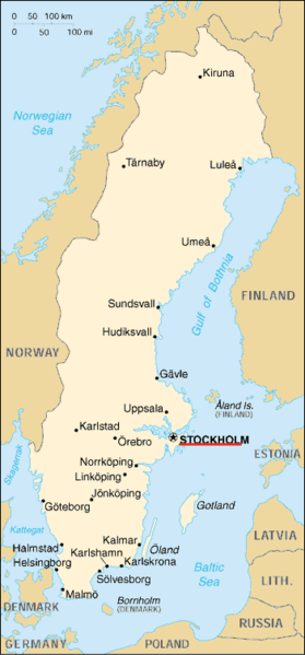
Location map of Stockholm.
Based on image:Sw-map,_CIA_World_Factbook.png
This image is in the public domain because it contains materials that originally came from the United States Central Intelligence Agency's World Factbook.
|
 |
Breytingaskrá skjals
Smelltu á dagsetningu eða tímasetningu til að sjá hvernig hún leit þá út.
| Dagsetning/Tími | Smámynd | Víddir | Notandi | Athugasemd | |
|---|---|---|---|---|---|
| núverandi | 13. febrúar 2007 kl. 05:04 | | 351 × 754 (20 KB) | Tene~commonswiki | Optimised (0) |
Skráartenglar
Eftirfarandi síða notar þessa skrá: