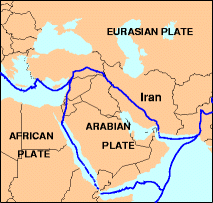
Mynd:Arabian tectonic plate overview map.png

Úr SignWiki
Jump to navigation Jump to search

Arabian_tectonic_plate_overview_map.png(213 × 203 mynddílar, skráarstærð: 19 KB, MIME-gerð: image/png)

Skrá þessi er af Wikimedia Commons, og deilt meðal annarra verkefna og nýtist því þar. Hér fyrir neðan er afrit af skráarsíðunni þar.

Lýsing

Lýsing
English: Overview map of the Arabian tectonic plate.
Dagsetning Óþekkt dagsetning
Unknown date
, uploaded 2012-01-17
Uppruni

http://neic.usgs.gov/neis/gifs/iran_plates.gif

Used in document: http://neic.usgs.gov/neis/eq_depot/2004/eq_040528/neic_jaan_ts.html

Tectonic Summary Magnitude 6.3 NORTHERN IRAN 2004 May 28 12:38:46 UTC
Höfundarréttarhafi U.S. Geological Survey

Leyfisupplýsingar:

Public domain
This work is in the public domain in the United States because it is a work prepared by an officer or employee of the United States Government as part of that person’s official duties under the terms of Title 17, Chapter 1, Section 105 of the US Code. Note: This only applies to original works of the Federal Government and not to the work of any individual U.S. state, territory, commonwealth, county, municipality, or any other subdivision. This template also does not apply to postage stamp designs published by the United States Postal Service since 1978. (See § 313.6(C)(1) of Compendium of U.S. Copyright Office Practices). It also does not apply to certain US coins; see The US Mint Terms of Use.

Original upload log

Dagsetning/Tími Víddir Notandi Athugasemd
17. janúar 2012, 13:29:04 213 × 203 (14751 bytes) Rwendland (spjall · framlög)

Captions

Add a one-line explanation of what this file represents

Items portrayed in this file

depicts enska

media type enska

image/png

checksum enska

b084b44bba70898c5460cd77440771b33d1e5601

data size enska

19.180 Bæti

203 díll

213 díll

Breytingaskrá skjals

Smelltu á dagsetningu eða tímasetningu til að sjá hvernig hún leit þá út.

Dagsetning/TímiSmámyndVíddirNotandiAthugasemd
núverandi17. ágúst 2014 kl. 19:48Smámynd útgáfunnar frá 17. ágúst 2014, kl. 19:48213 × 203 (19 KB)GifTaggerBot: Converting file to superior PNG file. (Source: Arabian_tectonic_plate_overview_map.gif). This GIF was problematic due to transparency and non-greyscale color table.

Eftirfarandi 2 síður nota þessa skrá: